
By Izzy Wallace
Photos courtesy Daniel Warn
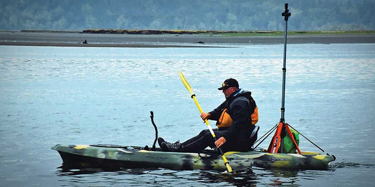
Brian Footen is a man, on a mission, in a kayak – to digitally map the 1,200 miles that make up the Salish Sea’s (aka Puget Sound) Nearshore.
Footen is president of EarthViews, a team dedicated to mapping out bodies of water.
There are several main reasons for doing so, Footen said.
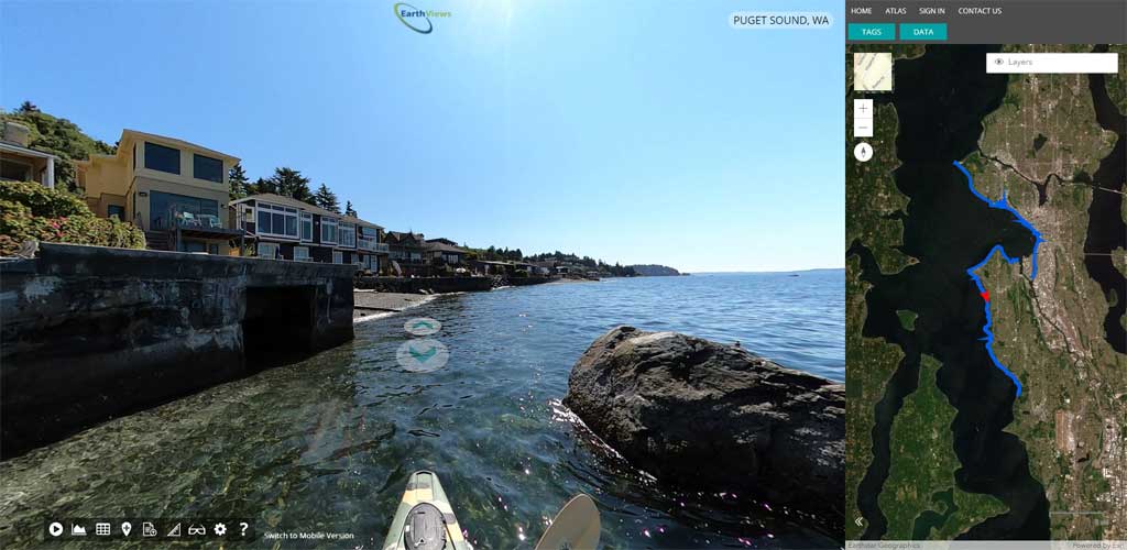
“The big overarching goal is so people can see places they may never get to go to,” he said. “All along the shoreline are really important aspects of what keeps Puget Sound healthy, and a functioning ecosystem. So by using this street view type technology, we believe this is a compelling way to show these places.”
Alongside this, having specific data of the area in 2021 will be important information to have for future generations.
“There’s going to be a digital archive of what the Puget Sound looked like in the early 21st century,” he said. “This is going to be a really great data set of imagery.”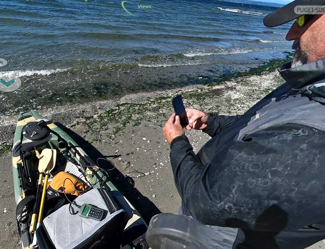
This digital footprint will also greatly benefit the local marine life. The area is a vital home to creatures such as orcas, harbor seals, salmon, and oysters, among many more.
Footen has also had a good deal of experience dealing with oceanic wildlife already. Before EarthViews, he was a fisheries research biologist for 20 years.
His time in this career helped him gain insight on what the needs are for the aquatic animals in the area, he said.
By tracking the area, conservationists can better understand what spots might be in trouble, what animals are coming and going, and what needs to be done to assist the marine animals.
This is needed now more than ever too, as water conditions in the Puget Sound have been reaching unsafe levels for the wildlife.
A major cause of this is from persistent bioaccumulative and toxic chemicals (PBTs), the Department of Ecology for Washington stated on their website.
PBTs are chemicals that break down very slowly in a natural environment, and are toxic when consumed by humans or other species. PBTs can often be found in different kinds of plastics, fabrics, and foam.
Because of this, now more than ever a virtual map is vital in bringing awareness of the water’s conditions to the surface.
This is another hope through this project – that by mapping and displaying the Puget Sound for the public to see, people may help take the extra steps needed to help protect the water’s wildlife.
“We hope to create a connection that carries over, to take a step forward to help to protect it too,” Footen said.
He is hoping to make it along all of the Puget Sound Nearshore by next year. “The goal is, this time next year or sooner, to map the whole Puget Sound,” he said. “We’re going to Olympia right now, but we’re going to keep going.”
The process of mapping out these waters and gathering this data is meticulous- it takes patience, equipment, and careful tracking.
“What we have is a kayak, we put this industrial tripod on top of it, then we have a GoPro MAX camera that goes on,” Footen said. This camera helps by taking 360 degree, panoramic photos.
A water quality meter is attached to the kayak as well, used to keep track of water conditions.
“The water quality meter and the camera are synchronized, they [both] go off every 10 seconds,” he said.
The equipment is also geolocated, so all data gathered from the meter and camera are pinned to specific points on the map- this is how wildlife seen along the way are tracked too.
“It shows points wherever we see whatever wildlife we find on the map,” Footen said.
He’s often been asked why a kayak is the boat of choice for this mapping. This is because a kayak allows Footen to get as close to the shore as possible, while still having good navigation, he said.
Overall, Footen is hoping to shine a spotlight to the area, and spread positivity by helping make a difference.
“There’s just a lot of attention right now on not only the degradation of the habitat, but also what needs to be done to help it,” he said. “I want to be part of that.”
VIDEOS
Below is portion of a video Footen shot during a recent mapping trip as he encounters a fallen tree near the shore:
And here’s an overview video about his project:
To learn more about the Puget Sound project and how you can help spread awareness, visit https://www.earthviews.com/puget-sound-vr/.
You can also find updates to the project on the See Puget Sound to Save Puget Sound Facebook page, at https://www.facebook.com/seepugetsound.
Izzy Wallace is a graduate from Highline College, where she got her AA in Multimedia, and her BAS in Integrated Design. She had previously worked at Highline’s newspaper for several years as Editor-in-Chief. You can send her ideas for news stories, or photos of your dogs, at shnizzle.my.izzle@gmail.com.