
An ‘Excessive Heat Watch’ has been issued by the National Weather Service, projected to run from this Wednesday, Aug. 11 through Saturday, Aug. 14, 2021.
While it won’t likely break the record-setting 108 degrees set at Sea-Tac Airport on June 27, 2021, it will still get quite toasty.
Weather experts say to expect hot conditions, with heat index values up to 98-100 possible, and warn:
“Extreme heat and humidity will significantly increase the potential for heat related illnesses, particularly for those working or participating in outdoor activities.”
URGENT – WEATHER MESSAGE
National Weather Service Seattle WA
304 AM PDT Mon Aug 9 2021
…EXCESSIVE HEAT WATCH REMAINS IN EFFECT FROM WEDNESDAY
AFTERNOON THROUGH SATURDAY EVENING…
* WHAT…Hot conditions with heat index values up to 98-100
possible. Puget Sound: 94-98 degrees. South Sound and Chehalis
Valley: 97-101 degrees. Western slopes of the Cascades: 92-98
degrees.
* WHERE…Portions of northwest and west central Washington.
* WHEN…From Wednesday afternoon through Saturday evening.
* IMPACTS…Extreme heat and humidity will significantly
increase the potential for heat related illnesses,
particularly for those working or participating in outdoor
activities.
* ADDITIONAL DETAILS…Nighttime relief Thursday, Friday and
Saturday morning will be poor across Eastern Puget Sound, the
adjacent Cascade foothills and in the Seattle metro area away
from the water. Overnight lows will be in the mid to upper 60s.
PRECAUTIONARY/PREPAREDNESS ACTIONS…
Monitor the latest forecasts and warnings for updates on this
situation. Be prepared to drink plenty of fluids, stay in an air-
conditioned room, stay out of the sun, and check up on relatives
and neighbors.
Young children and pets should never be left unattended in
vehicles under any circumstances. This is especially true during
warm or hot weather when car interiors can reach lethal
temperatures in a matter of minutes.
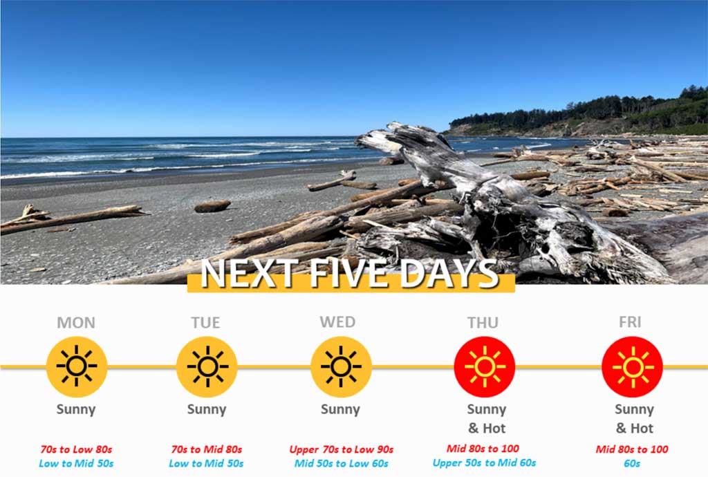
Here’s the detailed 7-day forecast:
-
- Monday: Sunny, with a high near 80. West northwest wind 3 to 7 mph.
- Monday night: Mostly clear, with a low around 58. North wind 8 to 10 mph.
- Tuesday: Sunny, with a high near 82. North northeast wind 6 to 9 mph.
- Tuesday Night: Mostly clear, with a low around 61. North wind 5 to 8 mph.
- Wednesday: Sunny, with a high near 87. North wind 5 to 10 mph.
- Wednesday Night: Mostly clear, with a low around 65.
- Thursday: Sunny, with a high near 94.
- Thursday Night: Mostly clear, with a low around 65.
- Friday: Sunny, with a high near 95.
- Friday Night: Mostly clear, with a low around 65.
- Saturday: Sunny, with a high near 92.
- Saturday Night: Mostly clear, with a low around 64.
- Sunday: Mostly sunny, with a high near 84.
Big time warm up still on track for Western Washington. Highs peaking in the 90s Thursday & Friday with low 100s possible in the warmest locations. Seattle record high Thursday 96° (1977), Friday 92° (2002). With offshore flow Thursday even coast will see 80s & lower 90s. #wawx pic.twitter.com/5hHwRbqkzn
— NWS Seattle (@NWSSeattle) August 9, 2021
As you can see on the map at https://t.co/JZtP9Jx5mJ excessive heat watches are now up for later this week. Here in Western WA it will be hot Thursday through Saturday (but not as hot as it was at the end of June). Here in Seattle we should see three days in the lower to mid 90s. pic.twitter.com/h95rMGi8KE
— NWS Seattle (@NWSSeattle) August 8, 2021