

Who needs spring when you can just leap frog right into summer? The National Weather Service (NWS) on Thursday, May 11, 2023 issued an “Excessive Heat Watch” starting Saturday afternoon and continuing through Monday afternoon.
NWS says to expect temperatures in the mid-80s to low-90s, which “will pose a moderate, to localized major, risk of heat-related illness.”
“Temperatures will warm on Friday into the mid 70s near the water, to low 80s across portions of the interior. Further warming expected on Saturday into Sunday, with daily record high temperatures possible, especially on Sunday,” NWS said in its forecast discussion. In addition, lows Sunday morning will range from the mid 50s to mid 60s, limiting cooling at night, and thus increasing heat-related impacts over the weekend.”
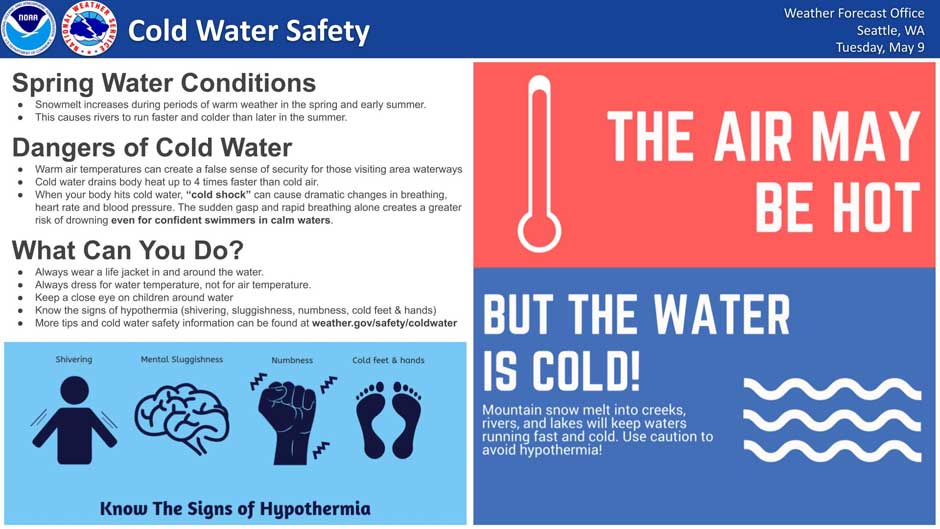
Cold Water Safety
Forecasters also warned of the dangers of cooling off in what will still be cold water:
“As for impacts during this heat event, the main focus will be on cold water safety, due to river and lake temperatures being in the 40s to mid 50s. It will be important to wear a life jacket, and also be aware of rivers running fast due to mountain snow melt. HeatRisk highlights moderate, with areas of major risk Saturday through Monday throughout Western Washington, lingering for the interior into Tuesday. This level of heat affects most individuals sensitive to heat, especially those without effective cooling or hydration.”
Excessive Heat Watch:
URGENT – WEATHER MESSAGE
National Weather Service Seattle WA
305 PM PDT Thu May 11 2023…EXCESSIVE HEAT WATCH REMAINS IN EFFECT FROM SATURDAY AFTERNOON
THROUGH MONDAY AFTERNOON…
* WHAT…Hot conditions with temperatures in the mid 80s to low 90s expected. This will pose a moderate, to localized major, risk of heat-related illness.
* WHERE…Portions of northwest and west central Washington.
* WHEN…From Saturday afternoon through Monday afternoon.
* IMPACTS…Heat will increase the risk of heat-related illnesses for those who are sensitive to heat, especially those without effective cooling or adequate hydration.
PRECAUTIONARY/PREPAREDNESS ACTIONS…
Monitor the latest forecasts and warnings for updates on this situation. Be prepared to drink plenty of fluids, stay in an air-conditioned room, stay out of the sun, and check up on relatives and neighbors.
Young children and pets should never be left unattended in vehicles under any circumstances. This is especially true during warm or hot weather when car interiors can reach lethal temperatures in a matter of minutes.
Here’s the latest video forecast from local Meteorologist Michael Snyder @SeattleWXGuy):

Detailed 7-Day Forecast:
- Thursday Night: Mostly clear, with a low around 51. North northeast wind around 7 mph.
- Friday: Mostly sunny, with a high near 79. North northwest wind 5 to 7 mph.
- Friday Night: Mostly clear, with a low around 56. North northeast wind 6 to 8 mph.
- Saturday: Sunny, with a high near 82. North wind 6 to 11 mph.
- Saturday Night: Clear, with a low around 59. North northeast wind 8 to 13 mph.
- Sunday: Sunny, with a high near 87.
- Sunday Night: Mostly clear, with a low around 62.
- Monday: Sunny, with a high near 88.
- Monday Night: Partly cloudy, with a low around 61.
- Tuesday: Mostly sunny, with a high near 80.
- Tuesday Night: Mostly clear, with a low around 58.
- Wednesday: Sunny, with a high near 79.
- Wednesday Night: Mostly clear, with a low around 58.
- Thursday: Sunny, with a high near 78.