
The National Weather Service on Tuesday morning, Dec. 27, 2022 issued a “High Wind Warning,” warning residents of increased winds of 30 to 40 mph with gusts up to 55 mph expected from 1 p.m. Tuesday afternoon to 1 a.m. Wednesday morning, Dec. 28.
NWS also issued at least three other warnings, and adds that widespread power outages should be expected, and that travel may be difficult, especially for high profile vehicles.
“Even if the winds do not reach high wind criteria, sustained 40 mph plus and/or gusts 58 mph plus with combination of a rapid increase in winds and the already saturated soils in the area increase the possibility of down trees/power outages,” NWS said in its forecast discussion.
FLOOD WATCH ISSUED
A Flood Watch was issued, warning that additional rains could push some rivers to flood stage by this evening and into Wednesday morning.
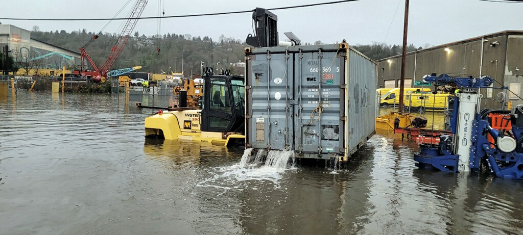
Burien resident John White sent us this photo, which shows flooding of a container at his pile driving business in South Park, which he attributes to rain and heavy snow melt on rivers.
“It’s bad, all our generators lost, etc…a disaster,” White told The B-Town Blog.
Here’s raw footage of some flooding in south Seattle courtesy KING5:
Flood Watch
National Weather Service Seattle WA
1142 AM PST Tue Dec 27 2022
.Rain, heavy at times, through today. Ground conditions are already saturated from previous storms. The additional rain today could push some rivers to flood stage by this evening and into Wednesday morning.
…FLOOD WATCH REMAINS IN EFFECT THROUGH WEDNESDAY MORNING…
* WHAT…Flooding caused by excessive rainfall continues to be possible.
* WHERE…Portions of northwest and west central Washington, including the following counties, in northwest Washington, Clallam, Grays Harbor, Island, Jefferson, Kitsap, Mason, San Juan, Skagit and Whatcom. In west central Washington, King, Lewis, Pierce, Snohomish and Thurston.
* WHEN…Through Wednesday morning.
* IMPACTS…Excessive runoff may result in flooding of rivers, creeks, streams, and other low-lying and flood-prone locations. Flooding may occur in poor drainage and urban areas.
* ADDITIONAL DETAILS…
– The culmination of weekend snow and ice melt, as well as rains Monday and today will allow for rivers to continue to rise into early Wednesday, keeping the threat for river flooding in place.
– http://www.weather.gov/safety/flood
PRECAUTIONARY/PREPAREDNESS ACTIONS…
You should monitor later forecasts and be alert for possible Flood Warnings. Those living in areas prone to flooding should be prepared to take action should flooding develop.
Local @SeattleWXGuy Michael Snyder released his latest video forecast Tuesday morning (subscribe to his YouTube channel here):
And a Windstorm Update from Monday night, Dec. 26, 2022:
High Wind Warning
URGENT – WEATHER MESSAGE
National Weather Service Seattle WA
339 AM PST Tue Dec 27 2022
…HIGH WIND WARNING IN EFFECT FROM 1 PM THIS AFTERNOON TO 1 AM PST WEDNESDAY…
* WHAT…Southwest winds 30 to 40 mph with gusts up to 55 mph expected.
* WHERE…Southwest Interior, Tacoma Area, Seattle and Vicinity and Bremerton and Vicinity.
* WHEN…From 1 PM this afternoon to 1 AM PST Wednesday.
* IMPACTS…Damaging winds will blow down trees and power lines. Widespread power outages are expected. Travel will be difficult, especially for high profile vehicles.
* ADDITIONAL DETAILS…Saturated soils from recent precipitation will make it easier for trees to come down.
PRECAUTIONARY/PREPAREDNESS ACTIONS…
People should avoid being outside in forested areas and around trees and branches. If possible, remain in the lower levels of your home during the windstorm, and avoid windows. Use caution if you must drive.
Coastal Hazard Message
National Weather Service Seattle WA
344 AM PST Tue Dec 27 2022
…COASTAL FLOOD ADVISORY IN EFFECT FROM 8 AM THIS MORNING TO 1 PM PST THIS AFTERNOON…
* WHAT…Minor coastal flooding expected.
* WHERE…Everett and Vicinity, Tacoma Area, Seattle and Vicinity and Bremerton and Vicinity zones.
* WHEN…From 8 AM this morning to 1 PM PST this afternoon.
* IMPACTS…Flooding of lots, parks, and roads with only isolated road closures expected.
PRECAUTIONARY/PREPAREDNESS ACTIONS…
If travel is required, allow extra time as some roads may be closed. Do not drive around barricades or through water of unknown depth. Take the necessary actions to protect flood-prone property.
Here’s the 7-day detailed forecast:
-
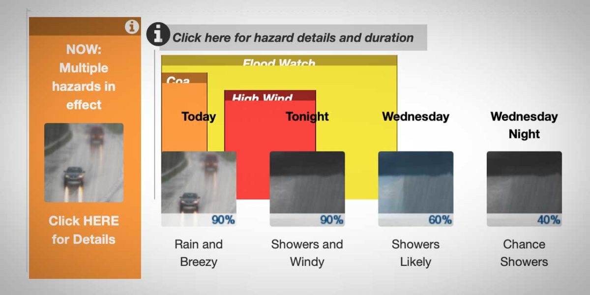
- Tuesday: Rain. Temperature falling to around 46 by 5pm. Breezy, with a south southwest wind around 25 mph, with gusts as high as 36 mph. Chance of precipitation is 90%. New precipitation amounts between a tenth and quarter of an inch possible.
- Tuesday Night: Showers. Low around 40. Windy, with a southwest wind 22 to 31 mph, with gusts as high as 40 mph. Chance of precipitation is 90%. New precipitation amounts of less than a tenth of an inch possible.
- Wednesday: Showers likely, mainly before 4pm. Mostly cloudy, with a steady temperature around 42. South southwest wind 13 to 15 mph, with gusts as high as 20 mph. Chance of precipitation is 60%. New precipitation amounts of less than a tenth of an inch possible.
- Wednesday Night: A chance of showers before 10pm, then a chance of rain after 10pm. Mostly cloudy, with a low around 39. Southeast wind 6 to 8 mph. Chance of precipitation is 40%.
- Thursday: Rain. High near 44. South southeast wind around 6 mph. Chance of precipitation is 90%. New precipitation amounts between a quarter and half of an inch possible.
- Thursday Night: Rain. Low around 42. Chance of precipitation is 90%. New precipitation amounts between a quarter and half of an inch possible.
- Friday: Rain. High near 47. Chance of precipitation is 90%.
- Friday Night: A chance of showers. Mostly cloudy, with a low around 40.
- Saturday: A chance of showers. Mostly cloudy, with a high near 45.
- Saturday Night: A chance of showers before 10pm. Mostly cloudy, with a low around 39.
- New Year’s Day: Mostly cloudy, with a high near 44.
- Sunday Night: A chance of rain. Mostly cloudy, with a low around 36.
- Monday: Rain likely. Cloudy, with a high near 42.
#wawx Wind speeds have been trending down a bit with this storm, still a couple 50-55mph gusts Seattle towards Portland possible, with strong westerly surge coming down straight of Juan De Fuca, some disagreement on how far east the surge gets towards I-5 however. pic.twitter.com/HLarckZ1b1
— Michael Snyder (@SeattleWXGuy) December 27, 2022
My mobile station got to 975mb this morning, (28.79)
He is all alone out there on a random dune on the Washington coast with a low battery since I had it in the vehicle all day and he lost out of the solar power charging. Hopefully it is getting a few sun breaks today. pic.twitter.com/kB8E91eEKI— Michael Snyder (@SeattleWXGuy) December 27, 2022
Barometer way, WAY down this morning… waiting for the big pressure rise. #Windstorm #Wind #Seattle #Portland #wawx #orwx pic.twitter.com/6P17RkWHcj
— Michael Snyder (@SeattleWXGuy) December 27, 2022
Huge storm hammers the West Coast of North America! https://t.co/HMF9NiQyBp via @YouTube pic.twitter.com/UIzxP6xcPD
— Michael Snyder (@SeattleWXGuy) December 27, 2022
The HRRR just went all in. #wawx pic.twitter.com/LMLxTnvD90
— Michael Snyder (@SeattleWXGuy) December 27, 2022