
The National Weather Service is predicting that a “frontal system will bring a threat of lowland snow later Saturday into Sunday (Feb. 25-26) with light accumulations expected.”
“The weather gets interesting Saturday afternoon and night. A front will move through the area, bringing a shot of precipitation.
“A cool and showery pattern will continue the first half of next week for a rain/snow mix possible for the lowlands at times,” NOAA said.
Over the next five days or so, forecasters say we may get a total of around 2-3 inches of snow.
Low temps will range from around 25 to 37 degrees, and highs will reach around 44, which means that over the next week there may be a slushy mix of both the white and the wet stuff alternating.
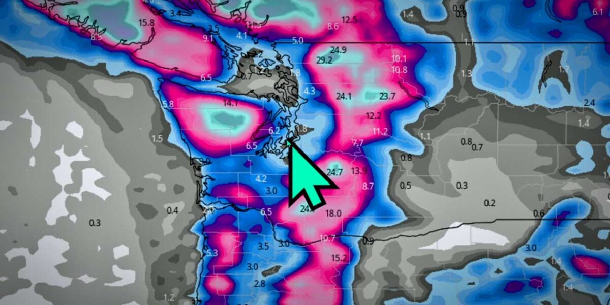
Local meteorologist Michael Snyder (@SeattleWXGuy) concurs – here’s his latest forecast video:

Help the Burien Severe Weather Shelter
Burien’s Severe Weather Shelter (located at Highline United Methodist Church; map below) will remain open as long as lows are 32 or below, and they could use volunteers and donations.
“Please help us provide for our unhoused neighbors and those with inadequate heat sources,” organizers said.
Organizers have added volunteer spots through the weekend and could still use the following supplies for Friday dinner – please be sure to use the signup link below so they know what ingredients are already taken care of:
- Ground Beef
- Corn meal
- Canned diced green chilies
- Canned sliced black olives
- Salad mix
- individually wrapped dessert items (homemade is great!)
Sign up here
Detailed Forecast:
- Friday: Sunny, with a high near 37. Wind chill values between 16 and 26. North wind 8 to 11 mph.
- Friday Night: Partly cloudy, with a low around 25. East wind 3 to 7 mph.
- Saturday: Rain and snow likely after 4pm. Increasing clouds, with a high near 42. Wind chill values between 23 and 33. Light and variable wind becoming south 5 to 8 mph in the morning. Chance of precipitation is 60%. New snow accumulation of less than a half inch possible.
- Saturday Night: Rain and snow likely before 10pm, then snow between 10pm and 1am, then rain and snow after 1am. Low around 34. South southwest wind around 10 mph. Chance of precipitation is 90%. New snow accumulation of around an inch possible.
- Sunday: Rain and snow, becoming all rain after 10am. High near 43. Southwest wind 5 to 10 mph increasing to 12 to 17 mph in the afternoon. Winds could gust as high as 23 mph. Chance of precipitation is 80%. Little or no snow accumulation expected.
- Sunday Night: A chance of rain and snow before 10pm, then a chance of snow. Mostly cloudy, with a low around 32. Chance of precipitation is 50%. New snow accumulation of less than a half inch possible.
- Monday: Snow likely before 1pm, then rain likely. Mostly cloudy, with a high near 44. Chance of precipitation is 60%. New snow accumulation of less than a half inch possible.
- Monday Night: Rain likely before 7pm, then rain and snow likely. Mostly cloudy, with a low around 33.
- Tuesday: A chance of snow before 10am, then a chance of rain. Mostly cloudy, with a high near 42.
- Tuesday Night: A slight chance of rain and snow before 10pm. Mostly cloudy, with a low around 30.
- Wednesday: A slight chance of rain. Partly sunny, with a high near 44.
- Wednesday Night: Rain and snow likely. Mostly cloudy, with a low around 37.
- Thursday: Rain. Mostly cloudy, with a high near 45.
Burien’s Severe Weather Shelter is located at Highline United Methodist Church, 13015 1st Ave S, Burien, WA 98168: