
The National Weather Service on Thursday morning (Dec. 22, 2022) issued a “Winter Storm Watch,” warning residents that – starting at 4 p.m. Thursday and continuing through Friday evening – a “heavy mixed precipitation” is possible, with total snow accumulations of “up to three inches, and ice accumulations of up to a quarter of an inch possible.”
NWS says that precipitation may begin as snow before transitioning to sleet, freezing rain, and eventually good ol’ fashioned rain (remember that?), and adds:
“A series of systems will then move through the region over the weekend and into next week, bringing warmer temperatures, heavier rainfall, and an increasing risk of urban and river flooding.”
If you’ve adopted a storm drain, you might want to haul out the rake and check to make sure they’re cleared.
Be prepared also for possible (or probable) power outages, as freezing rain and ice can break branches, knock trees over and disrupt the electrical grid quickly. Check for Seattle City Light outages here, and Puget Sound Energy here.
Winter Storm Watch
URGENT – WINTER WEATHER MESSAGE
National Weather Service Seattle WA
424 AM PST Thu Dec 22 2022
…WINTER STORM WATCH REMAINS IN EFFECT FROM 4 PM PST THIS AFTERNOON THROUGH FRIDAY EVENING…
* WHAT…Heavy mixed precipitation possible. Total snow accumulations of up to three inches and ice accumulations of up to a quarter of an inch possible.
* WHERE…Portions of northwest and west central Washington.
* WHEN…From 4 PM PST this afternoon through Friday evening.
* IMPACTS…Plan on slippery road conditions.
* ADDITIONAL DETAILS…This is will be a complex mix of winter precipitation with potentially significant impacts..
PRECAUTIONARY/PREPAREDNESS ACTIONS…
Monitor the latest forecasts for updates on this situation.
Local @SeattleWXGuy Michael Snyder released his analysis Thursday morning:
Join Snyder’s YouTube channel here to help support the Pacific Northwest Weather Watch.
Here’s another analysis from the Washington Weather Chasers:
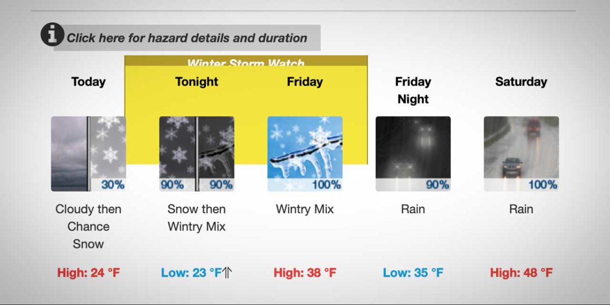
Here’s the detailed 7-day forecast:
-
- Thursday: A 30 percent chance of snow after 4pm. Cloudy, with a high near 24. Wind chill values between 6 and 14. East southeast wind 10 to 13 mph, with gusts as high as 22 mph. Total daytime snow accumulation of less than a half inch possible.
- Thursday Night: Snow before 4am, then snow, possibly mixed with freezing rain. Temperature rising to around 26 by 5am. Wind chill values between 12 and 17. East southeast wind around 10 mph. Chance of precipitation is 90%. Little or no ice accumulation expected. New snow accumulation of less than a half inch possible.
- Friday: Freezing rain, possibly mixed with snow before 1pm, then rain. High near 38. Wind chill values between 16 and 26. South southeast wind around 7 mph. Chance of precipitation is 100%. New ice accumulation of less than a 0.1 of an inch possible. Little or no snow accumulation expected.
- Friday Night: Rain. Low around 35. South wind around 7 mph. Chance of precipitation is 90%. New precipitation amounts between a tenth and quarter of an inch possible.
- Saturday: Rain. High near 48. South wind 7 to 10 mph. Chance of precipitation is 100%. New precipitation amounts between three quarters and one inch possible.
- Saturday Night: Rain, mainly before 10pm. Low around 42. Chance of precipitation is 90%. New precipitation amounts between a tenth and quarter of an inch possible.
- Christmas Day: Rain, mainly after 10am. High near 49. Chance of precipitation is 80%.
- Sunday Night: Rain. Cloudy, with a low around 45.
- Monday: Rain. Cloudy, with a high near 51.
- Monday Night: Rain. Cloudy, with a low around 44.
- Tuesday: Rain. Cloudy, with a high near 49.
- Tuesday Night: Rain. Cloudy, with a low around 43.
- Wednesday: Rain. Cloudy, with a high near 48.
️ FREEZING RAIN UPDATE!
Here’s the latest freezing rain ice accumulation animation for this evening thru SUN AM. We’re very concerned about the FRI AM commute across the Puget Sound & pass travel. That said, ice accumulation will be possible anywhere in western WA. #wawx pic.twitter.com/YzLS3jVDbJ— NWS Seattle (@NWSSeattle) December 22, 2022
Incoming unusual Ice Storm and no warnings up from NWS Seattle. Dangerous conditions are imminent and people need to have heads up, airport likely to be shut down for a time, ice coating everything. Extremely Dangerous mountain travel, communication is key! #wawx pic.twitter.com/j4IUZjRKPo
— Michael Snyder (@SeattleWXGuy) December 22, 2022
Garret Hartung @HartungWx Is Live at the Vista House in the Gorge of the Columbia River #orwx #wawx #Windhttps://t.co/T5cBDG7TrV
— Michael Snyder (@SeattleWXGuy) December 22, 2022
This is no joke. This is going to make for REALLY challenging traveling conditions on what is one of the busiest travel days of the year. It’s vital if you’re driving that you & your vehicle are prepared, including prepared for delays/closures. https://t.co/08r6R1Kv7A
— Washington State DOT (@wsdot) December 22, 2022
Jaws Music starts… #WinterStorm pic.twitter.com/ftkj5rdYIw
— Michael Snyder (@SeattleWXGuy) December 22, 2022
ICICLE REMOVAL
Three left lanes on northbound I-5 underneath the Seattle Convention Center in downtown are currently closed while our maintenance crews remove some large icicles from the tunnel ceiling. Please slow down when approaching this work zone and expect delays. ♂️ ♀️ pic.twitter.com/LtI4WzlnVu
— WSDOT Traffic (@wsdot_traffic) December 22, 2022
Thursday 12/22 Recology Update
No residential service in the following cities
Bothell-Burien-Carnation-Issaquah-Mercer Island-Shoreline-SeattleWe are servicing residents in the following cities
SeaTac-Des Moines-Maple ValleyVisit our website for more https://t.co/vvbglff72d
— Recology King County (@RecologyKC) December 22, 2022
Folks, we’re seeing big backups with travelers trying to get to @flySEA along westbound SR 518 and southbound I-405 in #SeaTac #Tukwila right now. Holiday travel is in full swing. #PlanAhead and give yourself extra time to get to the airport. ⚠️✈️ #KnowBeforeYouGo https://t.co/M3SE3nDeQ0 pic.twitter.com/c92LKSVZL1
— WSDOT Traffic (@wsdot_traffic) December 22, 2022