
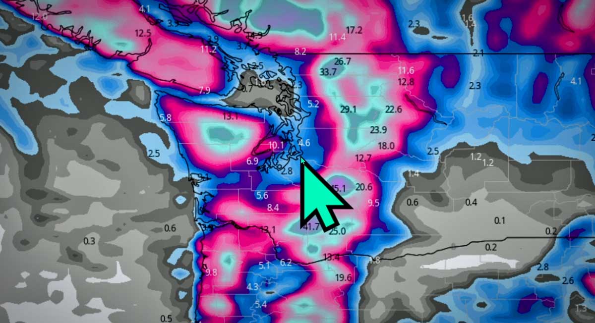
The National Weather Service issued a ‘Winter Weather Advisory’ starting Saturday night, Feb. 25, continuing through Sunday morning, Feb. 26, 2023.
Wet snow is expected, with a total snow accumulations of up to two inches forecast.
Due to temperature fluctuations though, it will more likely be a wintery mix with sporadic snow showers.
“The result is a messy and complicated lowland snow forecast,” NWS said in its forecast discussion.
Local @SeattleWXGuy Michael Snyder agreed that this is “a very tricky forecast”:

The Winter Weather Advisory is for most of the Puget Sound region:
Winter Weather Advisory
URGENT – WINTER WEATHER MESSAGE
National Weather Service Seattle WA
1212 PM PST Sat Feb 25 2023…WINTER WEATHER ADVISORY IN EFFECT FROM 6 PM THIS EVENING TO 10 AM PST SUNDAY…
WHAT…Wet snow expected. Total snow accumulations of up to two inches.
WHERE…Tacoma and vicinity, including Vaughn, Gig Harbor, Fox Island, Anderson Island, DuPont, Puyallup, and Spanaway, Admiralty Inlet Area, including Port Townsend, Whidbey Island, and Camano Island, Bellevue and vicinity, including Mill Creek, Kenmore, Kirkland, and Issaquah and Seattle and vicinity, including Shoreline, Vashon Island, Mercer Island, White Center, Kent, and Algona.
WHEN…From 6 PM this evening to 10 AM PST Sunday.
IMPACTS…Plan on slippery road conditions.
PRECAUTIONARY/PREPAREDNESS ACTIONS…
Slow down and use caution while traveling.
For the latest road conditions in Washington state, call 5 1 1.
Detailed Forecast:
- Saturday Afternoon: Mostly cloudy, with a high near 42. South southwest wind around 9 mph.
- Saturday Night: Rain and snow, mainly before 5am. Low around 34. South southwest wind 8 to 10 mph. Chance of precipitation is 100%. New snow accumulation of around an inch possible.
- Sunday: A chance of rain and snow showers before 11am, then rain showers likely between 11am and 5pm, then rain and snow showers likely after 5pm. Partly sunny, with a high near 42. Southwest wind 7 to 12 mph increasing to 13 to 18 mph in the afternoon. Winds could gust as high as 25 mph. Chance of precipitation is 60%. Little or no snow accumulation expected.
- Sunday Night: Rain and snow showers likely before 10pm, then a chance of snow showers. Mostly cloudy, with a low around 31. South southeast wind 6 to 13 mph. Chance of precipitation is 60%. New snow accumulation of less than a half inch possible.
- Monday: Snow showers likely before 1pm, then rain showers likely. Mostly cloudy, with a high near 42. East southeast wind around 7 mph. Chance of precipitation is 70%. New snow accumulation of less than a half inch possible.
- Monday Night: Rain showers likely before 7pm, then rain and snow showers likely between 7pm and 1am, then a chance of snow showers after 1am. Mostly cloudy, with a low around 34. Chance of precipitation is 70%. New snow accumulation of less than a half inch possible.
- Tuesday: Snow showers likely before 1pm, then rain showers likely. Mostly cloudy, with a high near 42. Chance of precipitation is 60%. New snow accumulation of less than a half inch possible.
- Tuesday Night: A chance of rain showers, mixing with snow after 7pm, then gradually ending. Mostly cloudy, with a low around 30.
- Wednesday: A slight chance of snow between 10am and 1pm, then a chance of rain. Mostly cloudy, with a high near 42.
- Wednesday Night: A chance of rain before 7pm, then snow, possibly mixed with rain. Mostly cloudy, with a low around 36.
- Thursday: Rain and snow. Cloudy, with a high near 44.
- Thursday Night: Rain and snow. Mostly cloudy, with a low around 35.
- Friday: Rain and snow likely. Mostly cloudy, with a high near 44.
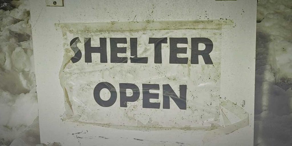
Burien Severe Weather Shelter update
Organizers at the Burien Severe Weather Shelter – which is open as long as lows hit 32 degrees – are in need of donations and volunteers, and here’s how YOU can help:
Hello Community,
First, thank you so much for your generosity. Your gifts of food and time and financial support have helped us provide essential shelter to our unhoused neighbors. In light of the forecast, we are extending our opening through Monday night, and may need to extend further as the cold weather continues.
We have an urgent need for a volunteer to cook dinner Sunday night – if you can fill this role, please email the shelter at shelter.highlineumc@gmail.com & let us know right away so we can source ingredients for your menu.
We have a need for additional volunteers Sunday, Monday, and Tuesday to prepare and serve dinner & breakfast. Please use the sign up and, as always, email the shelter at shelter.highlineumc@gmail.com if you have any questions or concerns about volunteering.
We’ve added ingredients for additional dinners- please check the list and sign up to let us know if you can bring anything to help us prepare these meals. We’re also in need of:
• Men’s Pants & Underwear in sizes Small/Medium or 32/34
• Winter gloves
• Blankets (max size twin)
Thank you for helping us get through this winter as a community!
With gratitude,
The Burien Severe Weather Shelter