
A former Burien resident – who still has family ties in the area – is challenging the City’s stance on the width of the public right-of-way (ROW) along SW 172nd Street in the Three Tree Point neighborhood, claiming historical records are flawed.
Eric Hovland, a retired jet mechanic who grew up in the beach neighborhood and whose Dad still owns a house there, has conducted extensive historical research into the contested area, specifically the city’s assertion that SW 172nd Street’s public right-of-way is still 80 feet wide, as originally platted in 1907.
Hovland argues in his 75-page report that the right-of-way is significantly narrower, based on historical documents he compiled and shared with Burien city officials multiple times since 2022.
“As my 75-page slideshow/report breaks down in every detail, the disputed portion of the ROW was legally narrowed to 40-feet in 1916,” Hovland told The B-Town Blog. “The reference maps were not updated to show this. The history was forgotten. An additional portion of the ROW was vacated in 1930 and is documented on reference maps.”
Hovland says that modern reference maps need to be updated to include the 1916 change of the ROW from 80-foot wide Seacoma Blvd to the 40-foot-wide Geo. E. Sylvester Road Extension.
“The evidence clearly shows the paved portion is part of the 40-foot right-of-way dedicated as Geo. E. Sylvester Road Extension on August 7, 1916,” Hovland said.
He argues that at that time, a portion of the original right-of-way was legally vacated when the King County Commissioners narrowed the Road/ROW, as well as per the 1916 Change of Road Law.
City of Burien Responds
Burien city officials have consistently maintained that the entire 80-foot ROW still exists and is publicly accessible. In correspondence, Burien Development Manager Brian Tornow responded in a Feb. 24, 2025 letter to Hovland that the right-of-way, including paved and unpaved portions, remains publicly accessible and maintains varied widths, referencing a 2016 federal court ruling. According to the city, the ruling affirms public access to the entire width regardless of ownership specifics.
“The entire public street right-of-way was dedicated to the City of Burien for public use through a public easement,” Tornow wrote. He added that the city’s interpretation aligns with existing court rulings confirming public rights to the unpaved portions of the roadway and adjacent beach.
Hovland believes the city’s stance, relying heavily on the original 1907 plat, overlooks documented historical changes and road realignments made by King County commissioners in 1916 and again in 1930. Also, he claims the 2016 court ruling only applies to three of about 40 lots.
He alleges Burien has disregarded clear evidence of these adjustments.
Decades-Old Mapping Errors?
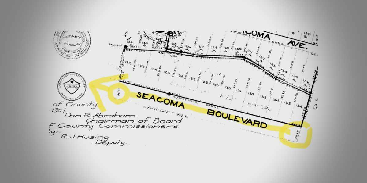
According to Hovland, historical records show that in 1915, King County residents petitioned to improve Seacoma Boulevard, which at the time was still a beach, and a further east section of road known as Automobile Avenue. The following year, after a county survey, the King County Commissioners officially rededicated the ROW’s as “Geo. E. Sylvester Road Extension”—which became what is known today as SW 172nd Street.
Hovland asserts that the county established the new ROW at widths of 40, 50, and 60 feet and that the southern 45 feet of the original Seacoma Boulevard ROW was vacated.
However, he says – except for the name – this critical change was never reflected on later maps, leading to decades of confusion over the true ROW dimensions.
“The answer is right there in the 1907 plat map, used as evidence in the 2016 court case,” Hovland said. “You can clearly see where Seacoma Boulevard was lined out and replaced with Sylvester Road and a bold line representing the 1930 vacation. The historical records prove that the 80-foot ROW was reduced decades ago, but the city refuses to acknowledge it.”

Legal and Expert Testimony in Dispute
Hovland’s findings contradict the City of Burien’s long-standing position, which he says has resulted in unnecessary restrictions and conflicts over the affected properties. He highlights the 2016 court case, where an expert witness for the city testified under penalty of perjury that:
“I have investigated the historical background of this street” … “It is this 80-foot span that is a dedicated public street and City right of way.”
Hovland disagrees with that assessment, pointing to official county records from 1916, 1922 and 1930 that document ROW modifications and vacations. He claims the city has overlooked key legal changes and misinterpreted historical surveys.
“How is it possible that the city ‘professionals’ we count on to be good at their job can’t interpret a plat map?” Hovland asked. “I’ve tried for years to work with the county and city to correct this issue, but they refuse and still currently claim an 80-foot ROW.”
Hovland continues to seek acknowledgment of his findings from city officials, while Burien maintains its position based on legal precedent.
Resources:
- Hovland’s 75-page slideshow presentation
- City of Burien’s Feb. 24, 2025 response letter
- City of Burien’s Brian Roberts Declaration
- United States District Judge Robert S. Lasnik’s Court Conclusion
- Soderlind v. Haigh Lawsuit
Our Previous Coverage:
- Three Tree Point beach cabanas ‘unlawful’ if unpermitted, city of Burien says
- City of Burien edited letter to Three Tree Point property owners before sending
I say seize it, raze it all and return it to a natural shoreline without all those un permited hovel’s blocking public access to the Sound.
That is essentially what the city will do. They have already served Legal paperwork explaining that the cost of the removal will be placed on the private property owners that built unlawfully unpermitted and illegal structures within the 30 foot King county roads. . Pharmer resident Eric Hovland Does not except that the road Is next to a body of water which could not be vacated unless a city or town had a reason to do so to create a marina or a recreational area but then it’s already dedicated to public use not private use and that’s where the homes on this particular stretch are in violation. I think things would be different if it was out in the country and it was just a dead end location, but this is a connector of Marine view Drive which ends suddenly in Normandy Park and picks up again and Gregory Heights. This is the only road that really connects And would otherwise be called Marine view Drive but the neighborhood is so old Seacoma Boulevard was created in 1906 and dedicated and accepted by the state and the county in 1907.
I believe the homeowners thought they could get away with this and now that they’re dealing with the consequences of their actions.. you should drive down there and tell me if it looks like a 30 foot wide road these structures aren’t connected to their private property in anyway except for the illegal utilities that were dug in and ran under the street without permits, like power, water and sewer, hook ups, and some cases all without permits.
Nobody would care if the residents weren’t such jerks to people trying to walk on the beach or drive on the ridiculously narrow road.
They clearly changed the ROW for cars. That doesn’t change the Easement. A ROW is based on an easement not the other way around.
Freddy, the city of Burien refers to the disputed land as ROW. That disputed land was legally vacated in 1916.
Ben, there are two public beach areas for anyone to freely use. The property owners own to extreme low tide and are heavily taxed on that property! From my experience, nobody has issues with people walking through their front yards (the beach) unless they are not being respectful.
Eric, you are too close to this to notice, but no. The owners of beach property in Burien tend to be very exclusionary to the public. They are probably all nice to you specifically because you are a part of that neighborhood. But if someone they don’t recognize walks past, they get yelled at to stay off their property. I know, because it has happened to me, and I’ve lived in Burien my whole life.
Moreover, this is a microcosm of the what’s going on in the country right now. The richest members of our little Burien community are trying to privately control and maintain what should belong to the community.
If you want to ask for lower tax basis, fine. But claiming that this land should belong to private owners instead of to the public community is a mockery. Of course, you’ll probably win, because the well off win everything they want these days. But that doesn’t make you right.
You’re exactly right Russell when you try to engage in rational discussions, they will belittle you telling you it’s complicated sophisticated and you just can’t understand. They’d have to have a lawyer contact you to explain it then you’ll be trespassed then they’ll make up a bunch of allegations their gang stalkers. I have to give some credit to the blog at first they were very one-sided, but it’s too hard to hide the truth, Henry Yesler purchased all the Tidelands fee, simple absolute. He needed them for his login company. Those have only been conveyed to his successor my family‘s predecessor when they short plaid, they did not sell any part of the 80 foot right of way. In fact it was dedicated for public use with conditions and restrictions. the Public has every rewrite to enjoy this beach because the 80 foot portion is tax free only recently Have we gotten King County accessor to tax them on their illegal encroachment and improvements some of them made up erroneous titles that did not hold water in the Registry of Deeds. The covenants created by Seacoma Beach improvement company protected the public interest. It was a neighborhood designed to be family, friendly, no intoxication or alcohol in the Public ROW, which is obviously not respected by these private property owners. They made this neighborhood as a safe haven for people who wanted to get away from the rough and tumbling streets of Seattle. I want to personally invite you, your friends and your family to enjoy the beaches here at Three Tree Point. Smile at the neighbors and if anybody questions, your presence, please video record document get their name and address and we will see to it that the city performs their duties to protect the citizens trying to enjoy their life
Thanks for posting this, I can see this documented as well and its supportive history after researching.
Interesting, do you have any documentation for this: ” they did not sell any part of the 80 foot right of way. In fact it was dedicated for public use with conditions and restrictions.”
-I have to agree the change of ROW in 1916 was very likely due to car traffic.
-Not to mention, a city can legally change a ROW. But If a city grants a permit for a structure and later changes the ROW, it could potentially lead to complications, but there are laws in place to protect property owners in such cases.
-Cities usually can’t retroactively force someone to destroy a legally permitted structure unless there’s a violation of some other law or safety standard, or the permit was granted under incorrect information or assumptions. If the ROW change impacts the structure, the city would typically need to provide compensation or allow for an alternative solution (e.g., modification of the structure rather than demolition).
This is the false statement the 80 foot dedicated public right of way has existed ever since it was dedicated. Eric‘s main argument is that somehow it was vacated and everybody had a legal right to take land within the 30 foot roadway that simply is not true some of the neighbors also claimed the beach was vacated and that was not true. Please see Washington state law.
RCW 35.79.035 Limitations on vacations of streets abutting
bodies of water—Procedure. (1) A city or town shall not vacate a
street or alley if any portion of the street or alley abuts a body of
fresh or salt water unless:
(a) The vacation is sought to enable the city or town to acquire
the property for port purposes, beach or water access purposes, boat
moorage or launching sites, park, public view, recreation, or
educational purposes, or other public uses;
(b) The city or town, by resolution of its legislative authority,
declares that the street or alley is not presently being used as a
street or alley and that the street or alley is not suitable for any
of the following purposes: Port, beach or water access, boat moorage,
launching sites, park, public view, recreation, or education; or
(c) The vacation is sought to enable a city or town to implement
a plan, adopted by resolution or ordinance, that provides comparable
or improved public access to the same shoreline area to which the
streets or alleys sought to be vacated abut, had the properties
included in the plan not been vacated.
(2) Before adopting a resolution vacating a street or alley under
subsection (1)(b) of this section, the city or town shall:
(a) Compile an inventory of all rights-of-way within the city or
town that abut the same body of water that is abutted by the street or
alley sought to be vacated;
(b) Conduct a study to determine if the street or alley to be
vacated is suitable for use by the city or town for any of the
following purposes: Port, boat moorage, launching sites, beach or
water access, park, public view, recreation, or education;
(c) Hold a public hearing on the proposed vacation in the manner
required by this chapter, where in addition to the normal requirements
for publishing notice, notice of the public hearing is posted
conspicuously on the street or alley sought to be vacated, which
posted notice indicates that the area is public access, it is proposed
to be vacated, and that anyone objecting to the proposed vacation
should attend the public hearing or send a letter to a particular
official indicating his or her objection; and
(d) Make a finding that the street or alley sought to be vacated
is not suitable for any of the purposes listed under (b) of this
subsection, and that the vacation is in the public interest.
(3) No vacation shall be effective until the fair market value
has been paid for the street or alley that is vacated. Moneys received
from the vacation may be used by the city or town only for acquiring
additional beach or water access, acquiring additional public view
sites to a body of water, or acquiring additional moorage or launching
sites. [1987 c 228 s 2.]
Guy, try reading my 75-page report linked to the story. It clearly documents two vacation actions approved by the King County Commissioners, first in 1916 and again in 1930. When a ROW is vacated the vacated portions go to the abutting properties.
RCW 35.79.035 DID NOT EXIST IN 1916 or 1930 !
Also, The ROW doesn’t abut a body of water. The ROW abuts private property, that private property then abuts the water! The RCW would not apply here.
I live on SW 172nd Street. I own my home and property from the north property line to low tide including land whether there is a right of way or not.
Washington law establishes ownership, use and privacy of my property. The King County Assessors Office assesses my property including my tide lands and I am taxed on all land, imprisonments and tide lands. The City of Burien does not own any portion of my property or any other residents property along SW 172nd Street.
The City of Burien ignores King County Council action in 1916 and 1930 that reduced the right of way from 80 feet to approximately 30 feet which is what it is today. The right of way starts on the north side of SW 172nd Street and does not reach tide lands.
The City of Burien has the power of Eminent Domain and under that authority can buy all the properties on SW 172nd Street and turn the properties into a public venue. Until that happens, my property is private as are all properties on SW 172nd Street.
I have lived on SW 172nd St. since 1998 and I have not once EVER yelled at anyone for walking on the beach, even tho my property title acknowledges that I own to extreme low tide, as does every property title along this street. This information is public record and available at King County Parcel Viewer. I pay taxes on the bulkhead on my property as does every resident on the street, and those who have structures across the street are paying taxes on those structures. I have seen a screen shot of my picture and my address posted on facebook by a particular individual who is spreading misinformation and posting lies about me and other residents on this street. This harassment is getting old and it needs to stop.
Looking to understand this situation a bit more, is this generally correct?
(You argue that the ROW was legally reduced to 40 feet in 1916, and the city is overlooking these changes. However, the city insists that even if parts of the ROW were vacated or altered, the public’s legal right to the full 80 feet still stands. The city argues that legal decisions and court rulings have already addressed these historical changes, even if the maps don’t fully reflect them.)
I guess I have to ask your thoughts on why your against having a 80ft ROW regardless of the map discrepancies? (which are very important to bring up and I fully understand how the map discrepancies are supportive evidence to your claim)
John M, most of the properties along the beach are only about 30-feet wide. The only place for most to park their vehicles is on their bulkheads. Many have temporary or permanent shelters for their vehicles to protect from the elements including sea water when the weather is active out of the south. Some also have cabanas for summer parties. For decades the city of Burien has harassed these people claiming these structures are on the ROW and want them torn down. Residents always believed the ROW was narrower, most deeds name the ROW as Sylvester Road, not Seacoma Blvd. It seems I was the first to actually thoroughly research it. Good Question, Thanks John!
Thanks for your response, yeah that sounds like some of these homes might be grand-fathered in depending on the build date/deed etc. The beach access is another subject though… wasn’t beach access allowed in WA state for public walkers, I’m not up to date on that though or complaining
( In regards to permanent structures)
Does anyone on 172nd have an approved permit of a permanent structure (a cabana or garage) built along the bulkhead? If so, wouldn’t that be seen as legal proof of the city acknowledging the 40’ROW at that time and approving that permit? Because the city wouldn’t issue permits for a permanent structure that violates zoning laws or encroaches on a public right-of-way.
John,
The issue of whether the public has the right to walk on a private beach has never been resolved by WA state Supreme Court. Here is a link to some info on that. https://www.pugetsoundinstitute.org/does-the-public-have-a-right-to-walk-across-a-private-beach-the-answer-is-still-unresolved/
In any case, all of us on SW 172nd St have land titles that say that we own to either extreme low tide (thats what mine and many others say) or to mean low tide. Regardless, I am not aware of anyone on this street that is mean to people walking on the beach as long as they access it at the public access point where Maplewild and SW 172nd meet.
Regarding structures, there are at least 2 houses with structures across the street that were permitted by King Co. before this area became part of Burien in 1993. I fail to understand why this continues to be such an issue when we all pay taxes on the land, structures, and bulkheads.
Carol, you’ve only been here since 1998
Didn’t you get a survey to prove that you supposedly own a private be didn’t you get a title report if you’re honest, please scan and copy that so that you could prove to the public and other officials that you owe some part of the land that was already previously dedicated . You’re about 90 years late to the party and it’s new neighbors like you that have made and join this neighborhood very difficult, especially making false clams that you own the public right of way is absurd. You can prove it by getting a certified survey and a title report that’s what all the 40 homes need to do And turn those into the city to prove your point why go in circles and use smoke and mirrors, leaving people lost in the weeds don’t retaliate against people who object to your unlawful orders.
Guy Soderlind, I have shared with you many deeds including a deed directly from Seacoma Beach Improvement Company indicating tidelands/beach were sold with properties including Carols lot.
Guy, instead of continually demanding the neighborhood to obtain surveys and title reports, how about you go spend some time in the archives and dig up any evidence you can to support your ridiculous claims!
John M, as far as I have researched, privately owned beaches are still private property in WA state.
The city can and has issued permits for structures in the ROW. I’m pretty sure I have copies of a couple in my records.
That makes sense on the beach case. Yeah I agree, cities issue lots of permits on ROWs but the details on a specific permit(s) issued (for a permanent structure inside a ROW) can be telling, might even be supportive to your side.
August 1950 Conveyance to Albin R. Soderlind and Charlotte J. Soderlind: In August 1950, John and Ruby Gilmore deeded to Albin R. Soderlind and Charlotte J. Soderlind, husband and wife, Tract 118-A, subject to conditions and restrictions in the 1907 deed to Mr. Brown and a deed from Seacoma Beach Improvement Company dated May 22,
1907. The deed was recorded in King County under Recording Number 4044654. A true and correct copy of the county’s transcription of the deed is attached as Exhibit 11 to this letter.
2008 Acquisition by Guy R. Soderlind: Guy R. Soderlind acquired his interest in Tract
118-A by a personal representative’s deed from the estate of Charlotte J. Soderlind in April 2008. The deed was recorded in King County on April 18, 2008 under Recording Number 2080418000828. A true and correct copy of the deed is attached as Exhibit 12
Guy, you are the current owner of lot 118A Seacoma Beach Div 1, no more, no less.
And your point is?
The History and Status of the South 172nd Street Right of Way 131226 2 DOCX
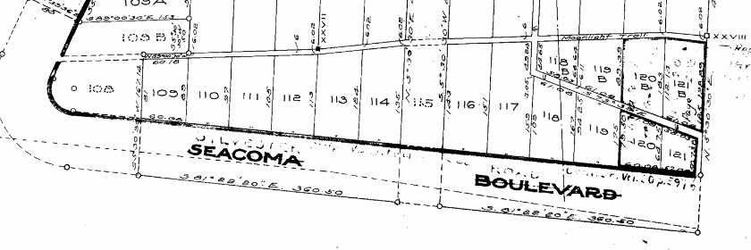
June 30, 1919. Secoma Beach Improvement Co to Mary S
Bishop lots 118 and 118A. 1321322755
Seattle trust co . Mary Bishop to Edgar Giboney lot 118&118b but didn’t include fee simple to 80’ public dedication retained by Mary Bishop in 1 class property 118 A The dedicator‘s residence, a location situated in which they could look over all of the locks being developed. They could see down onto the South Beach and to the left all the way to normally park the code they maintain trails through the lower half of 118 to access tidelands. For decades, certainly earning prescriptive easement rights they could look down and to the right off to the west and see all the homes all the way to the point the lighthouse they could see the lots on the north side, and in between, and when they looked to the north they could see Alki point and we still can . The home has spectacular views of Mount Rainier, Foster’s point Des Moines‘s Redondo Robinson point that’s on island all the Olympics from start to finish dolphin point black island Bainbridge .
The homes on Southwest 172 where are used for camping and commonly had tents. It wasn’t until the road came in that some of the homes started to be built but the 80foot dedicated property was fee, simple, absolute and dedicated with conditions and restrictions one of which is not to build obstructions or block, public access.
Guy, please help me make sense of your comment!
Are you saying the 80-foot wide Seacoma Blvd that was clearly one of the many streets dedicated/conveyed to the public and accepted by King County on the 1907 plat map was NOT dedicated to the public and is somehow part of your lot 118A?
Guy’s response summarized, seems to mean:
1. June 30, 1919 – Secoma Beach Improvement Co to Mary S. Bishop:
• On June 30, 1919, the Secoma Beach Improvement Company transferred ownership of lots 118 and 118A to Mary S. Bishop.
• The Recording Number associated with this transaction is 1321322755. This means the deed or transfer document was filed with a particular reference number in the county records.
2. Seattle Trust Co. and Mary Bishop to Edgar Giboney:
• After Mary Bishop acquired the land, she transferred lots 118 and 118A to Edgar Giboney.
• However, this transfer did not include the fee simple (full ownership rights) to an 80-foot public right of way that was retained by Mary Bishop. This 80-foot strip of land is part of the public dedication and was presumably kept for public access or other public uses.
3. 80’ Public Dedication Retained by Mary Bishop:
• This 80-foot strip was dedicated for public use and wasn’t part of the sale. The phrase “public dedication” suggests that Mary Bishop set aside this land for public purposes, such as a street, path, or other community access, and she didn’t transfer ownership of it to Edgar Giboney.
• The property is described as being on the south side of the Bishop’s residence, and the owner (or “dedicator”) had a residence located in a spot where they had a good view of the area.
4. The Dedicator’s Residence and Views:
• The location of the residence is described as having excellent views, including views of South Beach, Alki Point, Mount Rainier, the Olympic Mountains, and several other landmarks. This description emphasizes the scenic value of the location, with views stretching over significant parts of the region.
• The text mentions that the home had an unobstructed view and that the public could see the area from this location. This ties into the idea that the 80-foot public right of way was important for maintaining public access and preserving the views for both the owners and the community.
5. Trails and Tidelands:
• The 80-foot strip of land (the public right of way) was also used for trails that led down to the tidelands. Tidelands refer to land areas that are submerged or exposed with the rise and fall of the tide, which could be used for fishing, recreation, or other purposes.
• Over time, individuals used the trails in this area and gained prescriptive easement rights, which means they were using the path openly and without objection for a long period, potentially giving them legal rights to continue using the trail.
6. The Homes and Development on Southwest 172nd Street:
• The homes along Southwest 172nd Street were initially used for camping, and many had tents. This was likely before the road was properly developed, which allowed for more permanent homes to be built.
• The text also mentions that this development took place after the 80-foot public right of way was established.
7. Public Access and Restrictions on Building:
• The 80-foot dedicated property was a “fee simple” dedication, which means it was fully owned and freely transferred for public use.
• Conditions and restrictions were placed on the 80-foot strip, one of which was a restriction on building obstructions (such as structures or barriers) that would block public access to the area. This was likely to preserve the scenic views and ensure the land remained accessible for everyone.
________________________________________
In Summary:
Guy describes a series of property transactions dating back to 1919 involving several individuals and companies. It focuses on an 80-foot strip of land that was dedicated to public use and retained by the original owner (Mary Bishop), even though other parts of the property were sold to new owners. The public right of way was meant to ensure unobstructed access for both the residents and the public, preserving the views and access to nearby tidelands and scenic areas. Over time, people gained easement rights to the trails, and the property was used for recreational purposes, including camping, before more permanent homes were built.
The key points are about the public dedication, prescriptive easements, and the restriction on obstructing access to maintain the open, scenic, and accessible nature of the land.
And this summarized:
1. August 1950 – Conveyance to Albin R. Soderlind and Charlotte J. Soderlind:
o In August 1950, John and Ruby Gilmore transferred ownership of Tract 118-A to Albin R. Soderlind and Charlotte J. Soderlind (a married couple).
o This transfer was done via a deed, but the property transfer was subject to certain conditions and restrictions that were outlined in a 1907 deed (previously issued to a Mr. Brown) and another deed from the Seacoma Beach Improvement Company from May 22, 1907.
o The deed for this transaction was officially recorded in King County (which is likely a reference to King County, Washington, USA) under Recording Number 4044654.
2. 2008 Acquisition by Guy R. Soderlind:
o Guy R. Soderlind obtained his interest in Tract 118-A in April 2008.
o This acquisition happened through a personal representative’s deed from the estate of Charlotte J. Soderlind, which suggests that Charlotte had passed away, and Guy received the property as part of her estate.
o This deed was recorded in King County on April 18, 2008, under Recording Number 2080418000828.
• In 2008, after Charlotte’s death, Guy R. Soderlind (likely their heir) received the property through the probate process, and the transfer was officially recorded.
Guy,
1) Mary S Bishop did NOT purchase lot 118A.
2) Mary S Bishop did NOT sell lot 118A to Edgar Giboney.
3) Mary S Bishop did NOT own the 80-foot ROW. The 80-foot strip of land was conveyed/dedicated from Seacoma Beach Improvement Company to King County in 1907 according to the plats of Seacoma Beach Div. 1 and 2.
7) No conditions or restrictions are noted on the plat maps which conveyed the streets to the County.
Appears that a lot of supportive information is listed here, aside from additional recording numbers or document identifiers to make it easier to locate for a deep dig into the archives. The dates, names, and companies seem to be “legit”, so if these claims are apart of documented history, it would be found in the archives.
Guy, I have all those listed documents, and I have read them.
It appears you are the one who has not or cannot read them!
Mary S Bishop purchased lots 118 and 118B, NOT 118A!
I’m not “Guy” buddy, I am a guy though.
I found this bit of Burien history quite interesting. < as you can clearly see I am unbiased but interested to know the truth. – John M. Lowrance
John M. Lowrance, Guy has many aliases, and I believe you are one of them. When I asked Guy for clarity, you responded with your summary that was twice as long as the original statement! By repeating and expanding on Guys behalf you are clearly biased. If you are truly a third party and trying to understand the local history and Guy, you should be just as confused as I over his unfounded statements and demanding clarity with me.
Unforunately this was already well discussed over years of debate and has been solved in city/federal court. Anyone is in their right to challenge it again if they’d like
See city of burien’s last letter that Eric included and the federal court ruling for all answers/rulings that are current.
Current rulings stand.
It is unfortunate when someone does a deep dive into a subject, uncovers the truth, and upsets peoples long held beliefs.
We are over 30 comments now and nobody has proven any of my findings are wrong!
I dont think many people see your findings as something very changing to the law at all.. 100+ year old map dependencies? Its 2025 and the city has changed many things and will continue to into the future, including ROWs.
When really, your argument is about saving cabanas/garages and privatizing Beach access for a select few… so no I don’t think the “public” would view this as “poor residents on 172nd” at all when there are pressing arguments against yours and the court and city have decided on this case already. Cool old map plots though
First, I do not operate under any aliases or need any at my age. It’s important not to jump to conclusions about identity, especially when engaged in a discussion that hinges on facts, clarity, and respectful dialogue. ( That will make the people steer away from you)
Second, my intent in summarizing was not to obscure or defend anyone’s position, but to unpack a complex statement in good faith. The original version as I interpreted it – is quite confusing as you had mentioned— If the summary was longer, it was only to illuminate ambiguity, not to inject bias. ( Perception of text can be difficult )
Third, seeking clarity should be a shared goal. If something is unclear, it’s entirely reasonable to interpret and ask follow-up questions — not as a sign of bias, but as a step toward mutual understanding.
Fourth – After researching all sides and court cases, I have to agree with the city and federal court regardless of your findings. It was a interesting bit of history to learn about
Guy, end the childish games.
After all your research into the 100+ year old maps and documents, if you, or anyone else, has any evidence that any portion of my report is incorrect, please share it!
Well if you’d prefer, I’m open to meet in person anywhere in Burien to discuss this further over a coffee or something. Guess you feel the need to validate, which I’m ok with
Again, this “Guy” character seems to not care in responding hence the days of no responses above (creating a summary was not for just myself/you but for anyone else reading this forum Eric)… but you seem to know this “Guy” person well or at least crossed paths prior, so I’d be very interested to hear what you have to say in person
I live 40 miles north; however, I will be at lot 111 sometime after 3pm till maybe about 6pm Thursday April 24th to work on a few things on my dad’s rental house. If you see a silver VW Beetle parked there, I’ll be nearby. Sorry for the short notice. If you can’t make it, email me and I will give advanced notice of my next trip to Burien.
“John”, I believe Guy has been responding!
Eric, I’ve never heard of the Hovland family in Burien but I definitely have met and been helped by the Lowrance family over many years.
The Lowrance family has been around Burien forever, actively involved with St. Francis church, was involved with Burien’s early fire department and has helped within the Burien community as long as I’ve lived here. Reading this made me grin ear to ear.
-Jamie Delos Santos
Burien Auto Rebuild
Emailed, if you don’t see it – check junk folder(s)
“John M”, “After researching all sides and court cases” you have no comments regarding the history of the ROW in my report and you “agree with the city and federal court”?
You don’t question how the ROW can still be 80-feet after the 1930 vacation which is clearly noted on the current reference maps?
You don’t question how the cities “expert” could not possibly have not known about the 1930 vacation and misled the judge?
Buriens “expert” claims he studied the history including the Lot 109 deed which clearly mentions the 1930 vacation to the ROW!
The city “expert” submitted exhibit A in court, the 1907 plat map which has on it the 1930 vacation and the ROW name was changed to Sylvester Road, the new narrower 40-foot 1916 ROW!…. But still 80-feet?
Nobody questions why “Seacoma Blvd” is crossed out and “Sylvester Road” is all over the plat and survey maps?
And there is so so much more that is not in my report!!!
It could have been 1000 pages, but no one would have read it!
I believe you are Guy because you are avoiding the facts that brought us here and instead playing childish games trying to defend your existence. Anonymous comments are a First Amendment Right in America. And I have the Right to believe most of the commentors on this story are Guy. When I was told this was also on fascists book, I had the opportunity to “get to know” Guy.
If I’m wrong, I’m sorry I hurt your feelings!
NOW, Let’s talk about Geo. E. Sylvester Road Extension, please!
So I emailed you, check that out and you’ll understand everything. Good luck on everything Eric
John M, I read your email, I understand, you are a fraud and a liar!
I am here if ANYONE would like to have an honest discussion of Geo. E. Sylvester Road Extension or Burien’s hardline denial of it and other legal changes to the ROW.
So concluded, mental health crises are a serious public health concern that require attention and resources. Addressing these crises is essential to protect individuals, families, and society as a whole.
One can call 988 or your local county crisis line to request assistance or anyone else who is experiencing a behavioral/mental health crisis (24 hours, seven days a week, 365 days a year). Crisis lines are available for all Washingtonians, regardless of your insurance status or income level.
Eric, your choice in communicating is speaking volumes, and it’s clear its having a negative impact. The attitude you’re showing, marked by negativity and a sense of superiority is not helping this situation. Quite frankly, after reading your comments I wouldn’t trust any of your findings until I could review all of the historical documentation myself. If you didn’t come off this way, I probably would have just given you the benefit of the doubt but you didn’t.
Researching century-old maps and legal documents takes time as I’m sure you know, not gamesmanship. Brushing that off with a sarcastic challenge: “if anyone has evidence, share it!” that’s called posturing, which is not a genuine invitation for dialogue. You’re waiting to push someone down, so to speak. I believe your emotionally lashing out and using this blog to do so because your frustrated with this case.
Also, you demand others meet a standard of proof while refusing to engage with what’s already been presented. That’s not intellectual honesty. That’s called selective engagement.
If you want to defend your report, do it. But don’t pretend skepticism is immaturity just because it makes you uncomfortable. Have an open mind in solving problems, specially when its based solely on facts not personal opinion. And when your ready, go to court, not a public blog to present them.
The audience keeps expanding, unfortunately, the interest is in analyzing me instead of my report! …… Who I am should not matter. DON’T TRUST ME! DO YOUR OWN RESEARCH! ASK QUESTIONS! I HAVE NOTHING TO HIDE!
The documents I presented speak for themselves!
Please, what have I “refused to engage with”?
I’ve been continually begging for engagement related to my report and I’m still waiting to hear how lot 118A has any bearing on my report.
My report is a follow up to the 2021 story presented here, please explain why this public blog is an inappropriate space to share the true history of Seacoma Blvd, Sylvester Road Extension, and SW 172nd St.?
It absolutely matters, I can’t trust anything you’ve mentioned nor can I believe your 75 page report because its full of cherry-picked verbiage pertaining only to your claims. You easily could have brushed over any opposing documentation and not included it, and that’s me judging your character now because that’s all we’ve seen thus far. (Its also why blogs aren’t a good choice)
– Lastly there won’t be random Burien residents wanting to look up any of this historical documentation in the archives unless they are associated with your claims/172nd.
You know what parties will look into this? The courts and they already have. See their ruling or contest it in court
The Courts partial summary judgment is a fun topic which for some reason the city does NOT like to discuss!
It seems few have actually read it. A link to it is above.
The city thinks it covers the whole street, but it clearly states it only covers three of about 40 lots, lots 115, 116, and 117.
It’s clear, the judge based his decision on Burien’s “expert” Brian Roberts declaration. He declared under penalty of perjury, “I have investigated the historical background of this street”, and he obtained property reports for lots 109 & 110, and “It is this 80 foot span that is a dedicated public street and City right of way”.
The 1930 vacation and the 1916 Sylvester Road are clearly referenced in those documents and are also shown on his exhibit A, 1907 Seacoma Beach Div 1. plat map!
O’ my, Is that perjury?
Or is he saved by, “to the best of my knowledge”?
GIGO!
As I said before, the documents speak for themselves!
Of course, I “cherry picked” to support my claims, there must be well over a million documents in the archives!
Brian Roberts and Richard Beresford are the ones who “brushed over any opposing documentation” and did not include it!!!
Did the “court” discover that? NO, I did, and that information is in my report.
The BTownBlog is a great place to shine a light on this injustice.
As a random Burien resident, why are you so interested in this?
What about Guy Soderlinds babble about lot 118A?
Eric, I can vouch for John and so can many other Burienites. Hes a long time resident and a great person, along with his sprawling family.
But If you have something to prove in this case, you should do it in court. Public opinion will likely not be in your favor due many variables that you probably already know. Not sure what your expecting to hear on a public forum from folks who haven’t researched everything anyways. Best of luck to you and your endeavors
– Gregory P. Garcia