
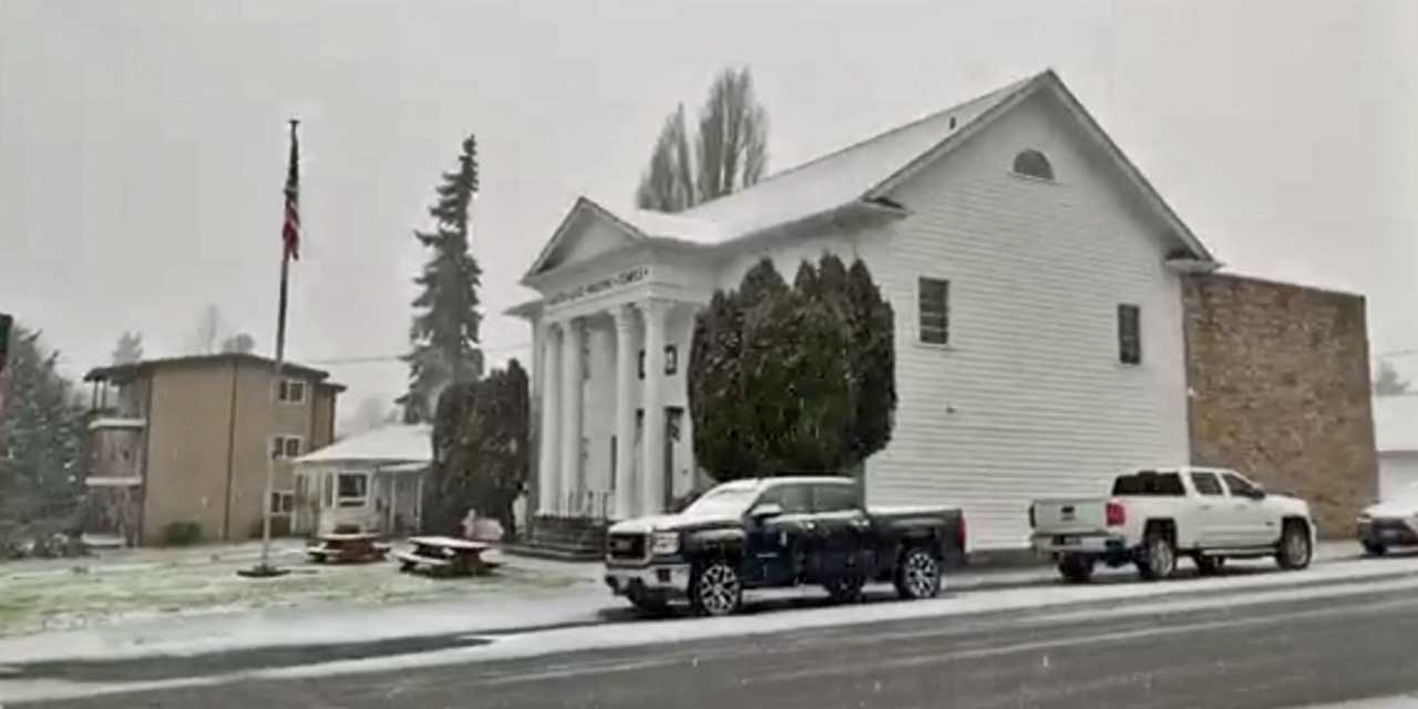
Have you winterized your home and/or yourself yet? Are you stocked up on food and beverages, and have you gotten chains or snow tires, or that generator you’ve been wanting yet?
We ask, because Normandy Park resident Michael Snyder – aka @SeattleWXGuy – has posted some updates on the potential for cold winter weather and snow for the region coming up, possibly starting with a White Christmas this Saturday.
Snyder works as an Alaska Airlines Aviation Weather guy/Flight Control, and is a longtime METAR instructor, Aviation Instructor, as well as former National Weather Service behind-the-scenes guy. He knows his weather.
“Seattle White Xmas watch!” Snyder Tweeted. “New EURO: SeaTac showing 0.9” of snow in previous 24 hours total at 10pm Christmas night, temperature falls below freezing between 4-10pm. We need 1” on the ground for a White Christmas, It’s going down to the wire!”
Here’s a video Snyder posted on Wednesday, Dec. 2021:

Here’s the detailed forecast from the National Weather Service:
Wednesday Afternoon: Rain. Steady temperature around 44. South wind around 11 mph. Chance of precipitation is 80%. New precipitation amounts of less than a tenth of an inch possible.
Wednesday Night: Rain. Low around 39. South southwest wind 11 to 15 mph, with gusts as high as 20 mph. Chance of precipitation is 80%. New precipitation amounts between a tenth and quarter of an inch possible.
Thursday: Showers likely, mainly after 4pm. Partly sunny, with a high near 43. Southwest wind 11 to 15 mph, with gusts as high as 20 mph. Chance of precipitation is 60%. New precipitation amounts of less than a tenth of an inch possible.
Thursday Night: Showers likely before 10pm, then rain likely after 10pm. Mostly cloudy, with a low around 36. South wind around 14 mph. Chance of precipitation is 70%. New precipitation amounts between a tenth and quarter of an inch possible.
Friday: Rain likely before 10am, then showers likely after 10am. Mostly cloudy, with a high near 42. South wind 9 to 11 mph. Chance of precipitation is 70%. New precipitation amounts between a tenth and quarter of an inch possible.
Friday Night: Showers likely. Mostly cloudy, with a low around 34. Chance of precipitation is 70%. New precipitation amounts between a tenth and quarter of an inch possible.
Christmas Day: Snow showers, possibly mixed with rain. High near 38. Chance of precipitation is 80%. New snow accumulation of less than a half inch possible.
Saturday Night: Snow. Mostly cloudy, with a low around 30.
Sunday: Snow likely. Mostly cloudy, with a high near 33.
Sunday Night: Snow likely, mainly before 10pm. Mostly cloudy, with a low around 21.
Monday: A chance of snow. Mostly cloudy, with a high near 28.
Monday Night: A chance of snow. Mostly cloudy, with a low around 21.
Tuesday: A chance of rain and snow. Mostly cloudy, with a high near 31.
Tuesday Night: A chance of rain and snow. Mostly cloudy, with a low around 20.
Wednesday: A chance of snow. Partly sunny, with a high near 29.
Here are some tips and info on winter weather from the City of Burien:
Winter weather, including snow, ice, and extreme cold, can put you and your home at risk. Follow these tips to stay safe and warm this winter:
Generators and charcoal BBQs cannot be used inside any structure, including a garage. The exhaust can kill you!
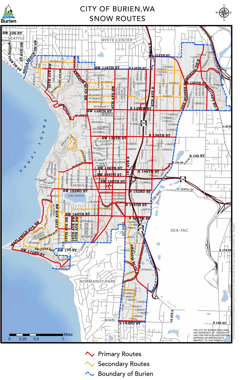
Stay off the roads as much as possible so our public works crews can get them plowed and sanded. When it snows, our plows will concentrate their efforts on primary snow removal routes first to accommodate fire, medical and police response, as well as Metro transit, school buses, and commuter traffic. As long as it continues to snow, these primary routes will be plowed.
If you have to venture out, slow down and give yourself lots of extra distance around other vehicles.
Your pets can’t handle the cold. Bring them inside and make sure their water is also inside so it doesn’t freeze.
Exposed water pipes will freeze and break. Disconnect your garden hoses and insulate your faucets.
If you or someone you know needs help with a warm place to stay, a hot meal, or an extra jacket, we have connections to resources in our community that can help. Burien Police Community Service Officer Michiko Wilson can be reached at (206) 477-2200.
If the power goes out, find out how to check the status of power restoration.
If you or a family member have emergency medical needs that will be severely impacted by a loss of power, please contact your power company and develop an emergency plan. Consider stocking up on all medicines and supplies prior to any severe weather event.
Clear your sidewalks and storm drains. Help your neighbors by removing snow and ice from the sidewalks in front of your property. Snow can plug storm drains and cause localized flooding.
Exercise caution in our parks. Snow and ice-laden trees can be dangerous and pathways may also be slippery.
“When it snows, City plows will concentrate their efforts on primary snow removal routes and de-icing routes first to accommodate fire, medical and police response, as well as Metro transit, school buses and commuter traffic,” the city said on its website. “As long as it continues to snow, these primary routes will be plowed.
“Once the snow has stopped and all primary roads are clear, plows will move to secondary snow removal routes, and once those are clear, neighborhood streets will be plowed.
“If it starts snowing again, the process of clearing main roads will start over.
“Please keep in mind that, during a heavy, continuous snowstorm, it may take several days before all city streets are cleared.”
The National Weather Service has also issued a Coastal Flood Advisory, warning of minor tidal overflow flooding possible around high tide on Thursday and Friday mornings.
Seattle White Xmas watch!
New EURO: Seatac showing 0.9” of snow in previous 24 hours total at 10pm Christmas night, temperature falls below freezing between 4-10pm. We need 1” on the ground for a white Christmas, It’s going down to the wire! #wawx pic.twitter.com/ISYbZYSBhr— Michael Snyder (@SeattleWXGuy) December 22, 2021
Last 3 EURO model temps for Seattle. Extreme cold near the end of December, but this is raw model output and it would be unprecedented since 1950. Would take PERFECT conditions for extremes to be realized (Clear sky, no wind, snow on ground, arctic airmass in place). #Seattle pic.twitter.com/LoVYpsxmSM
— Michael Snyder (@SeattleWXGuy) December 22, 2021
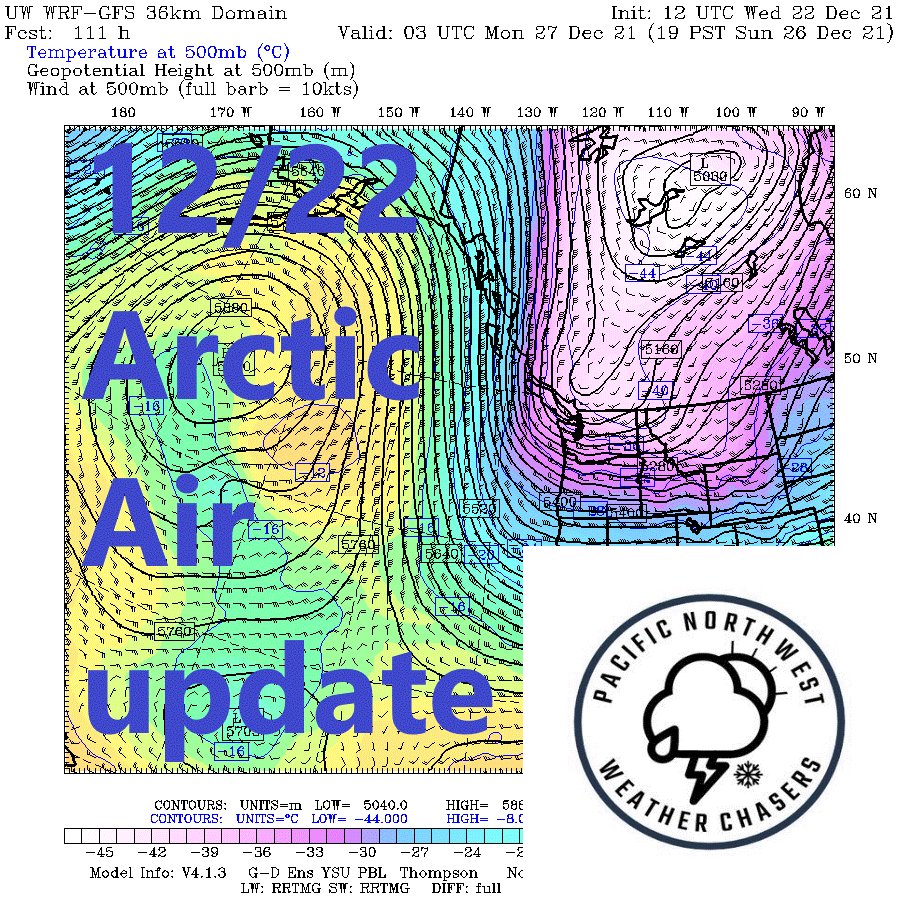
Xmas for Seattle looking like some snow will be around, but temps are marginal. GFS showing some 25+MB YWL-BLI gradient DEC 26th. Temps drop below freezing on DEC 26th and stay there for over a week. Several systems bring chances for snow through early January. #wawx #Seattle pic.twitter.com/0ZGtDgpGbl
— Michael Snyder (@SeattleWXGuy) December 22, 2021
Feels like time for an arctic outbreak hype video. #Video #snow #WINTER #storm pic.twitter.com/E7MhCP0fUN
— Michael Snyder (@SeattleWXGuy) December 21, 2021