
As we prepare to enter June-uary, B-Towners might want to batten down their blue tarps as on Friday the National Weather Service released a Flood Watch based on two atmospheric rivers that are expecting to arrive beginning Sunday night, June 2, 2024.
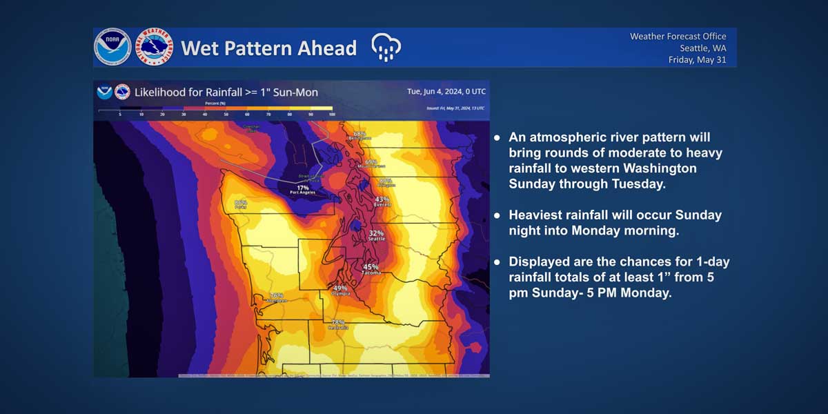
Meteorologists predict that this atmospheric river pattern will bring rounds of moderate to heavy rainfall to western Washington from Sunday through Tuesday.
“Generally, most locations have at least a 50% chance for seeing rainfall totals of at least 1 inch Sunday evening through Monday afternoon,” NWS said.
So if you happen to live near a creek or river, keep your eyes open and your boots handy.
The good news? “A warm up then looks to commence as high temperatures climb into the 70s and near 80 by Friday,” experts said.

Here’s the Flood Watch:
Flood Watch
National Weather Service Seattle WA
324 PM PDT Fri May 31 2024Two atmospheric rivers are expected to arrive beginning Sunday evening and lasting into Wednesday morning. Heavy rain is expected Sunday night into Monday morning for rises on area rivers and local creeks, some into action stage.
King-Mason-Pierce-Skagit-Snohomish-Including the cities of Anacortes, Tacoma, Sedro-Woolley, Mount Vernon, Seattle, Marysville, Edmonds, Burlington, Lynnwood, Everett, and Shelton
…FLOOD WATCH IN EFFECT FROM SUNDAY MORNING THROUGH WEDNESDAY MORNING…
* WHAT…Flooding caused by excessive rainfall is possible.
* WHERE…Portions of northwest and west central Washington, including the following counties, in northwest Washington, Mason and Skagit. In west central Washington, King, Pierce and Snohomish.
* WHEN…From Sunday morning through Wednesday morning.
* IMPACTS…Excessive runoff may result in flooding of rivers, creeks, streams, and other low lying and flood-prone locations. Creeks and streams may rise out of their banks. Flooding may occur in poor drainage and urban areas.
* ADDITIONAL DETAILS…
– http://www.weather.gov/safety/flood
PRECAUTIONARY/PREPAREDNESS ACTIONS…
You should monitor later forecasts and be alert for possible Flood Warnings. Those living in areas prone to flooding should be prepared to take action should flooding develop.
Detailed forecast:
- Friday night: A 30 percent chance of rain, mainly after 4am. Mostly cloudy, with a low around 52. North northeast wind 6 to 8 mph.
- Saturday: A 30 percent chance of rain, mainly before 9am. Cloudy, then gradually becoming mostly sunny, with a high near 64. Light and variable wind becoming south southwest 5 to 10 mph in the afternoon.
- Saturday Night: A 20 percent chance of rain before 11pm. Increasing clouds, with a low around 52. South southwest wind 7 to 10 mph.
- Sunday: Rain, mainly after 11am. High near 58. South wind 7 to 10 mph. Chance of precipitation is 100%. New precipitation amounts between a tenth and quarter of an inch possible.
- Sunday Night: Rain. Low around 53. South wind around 11 mph. Chance of precipitation is 100%. New precipitation amounts between a half and three quarters of an inch possible.
- Monday: Rain before 11am, then showers and possibly a thunderstorm after 11am. High near 60. Chance of precipitation is 100%. New rainfall amounts between a tenth and quarter of an inch, except higher amounts possible in thunderstorms.
- Monday Night: Showers likely and possibly a thunderstorm before 11pm, then rain likely after 11pm. Mostly cloudy, with a low around 50. Chance of precipitation is 70%.
- Tuesday: Rain. Mostly cloudy, with a high near 61.
- Tuesday Night: A chance of rain. Mostly cloudy, with a low around 50.
- Wednesday: A slight chance of rain before 11am. Mostly sunny, with a high near 68.
- Wednesday Night: Mostly clear, with a low around 51.
- Thursday: Sunny, with a high near 71.
- Thursday Night: Partly cloudy, with a low around 54.
- Friday: Mostly sunny, with a high near 74.
Here is a look at the period of heaviest rainfall with the upcoming atmospheric river pattern Sunday night through Monday. Generally, most locations have at least a 50% chance for seeing rainfall totals of at least 1 inch Sunday evening through Monday afternoon. 🌧️ #WAwx pic.twitter.com/pRiIJFQXdJ
— NWS Seattle (@NWSSeattle) May 31, 2024