
The National Weather Service on Monday morning, Dec. 26, 2022 issued a Special Weather Statement and Flood Watch, warning residents of heavy rainfall that could increase the threat of landslides and floods.
As numerous “atmospheric rivers” slam into our region, our ol’ friend rain will hang around for a while (hey, it’s better than ice storms and snow, right?), along with their buddy WIND.
Speaking of wind, NWS warns that gusts could hit as high as 45 mph on Tuesday night, Dec. 27, 2022.
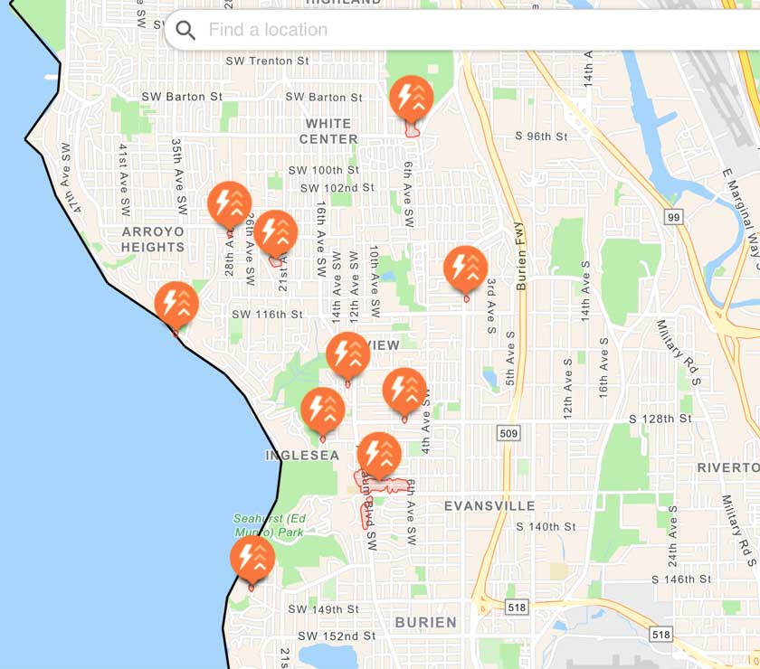
Power was also knocked out to over 300 Seattle City Light customers in the area Monday morning by the most recent storm system.
Local @SeattleWXGuy Michael Snyder released his latest video forecast Monday:
Special Weather Statement
National Weather Service Seattle WA
248 AM PST Mon Dec 26 2022
…HEAVY RAINFALL THROUGH TUESDAY AND RECENT SNOWMELT WILL LEAD TO AN INCREASED THREAT OF LANDSLIDES IN WESTERN WASHINGTON…
Rainfall of one to three inches over the past 24-36 hours combined with low elevation snowmelt has increased soil moisture to high levels across western Washington. Heavy rainfall of two to four inches is expected over the next few days. This amount of rain will put extra pressure on soil instability, leading to an increased threat of landslides.
For more information about current conditions, visit www.weather.gov/seattle, select Hydrology, and then scroll down for the links to the landslide information pages.
For more information on landslides, visit the website for the Washington State Department of Natural Resources landslide geologic hazards at: http://bit.ly/2mtA3wn
Flood Watch
National Weather Service Seattle WA
1033 AM PST Mon Dec 26 2022
Already wet conditions exist over Western Washington with another strong frontal system expected to enter the area tonight, resulting in additional rainfall Tuesday. Rivers are already seeing increases and the additional rainfall will result in some rivers potentially reaching flood stage.
…FLOOD WATCH IN EFFECT THROUGH WEDNESDAY MORNING…
* WHAT…Flooding caused by excessive rainfall is possible.
* WHERE…Portions of northwest and west central Washington, including the following counties, in northwest Washington, Clallam, Grays Harbor, Island, Jefferson, Kitsap, Mason, San Juan, Skagit and Whatcom. In west central Washington, King, Lewis, Pierce, Snohomish and Thurston.
* WHEN…Through Wednesday morning.
* IMPACTS…Excessive runoff may result in flooding of rivers, creeks, streams, and other low-lying and flood-prone locations. Flooding may occur in poor drainage and urban areas.
* ADDITIONAL DETAILS…
– The culmination of weekend snow and ice melt, a frontal system earlier today and another stronger frontal system expected tonight and Tuesday will exacerbate already rising river levels.
– http://www.weather.gov/safety/flood
PRECAUTIONARY/PREPAREDNESS ACTIONS…
You should monitor later forecasts and be alert for possible Flood Warnings. Those living in areas prone to flooding should be prepared to take action should flooding develop.
Here’s the 7-day detailed forecast:
-
- Monday: Rain, mainly after 3pm. Steady temperature around 49. South wind 5 to 9 mph, with gusts as high as 25 mph. Chance of precipitation is 80%. New precipitation amounts between a tenth and quarter of an inch possible.
- Monday Night: Rain. Low around 46. East southeast wind 6 to 14 mph, with gusts as high as 22 mph. Chance of precipitation is 100%. New precipitation amounts between a half and three quarters of an inch possible.
- Tuesday: Rain. Temperature falling to around 45 by 5pm. South southeast wind 15 to 17 mph, with gusts as high as 41 mph. Chance of precipitation is 100%. New precipitation amounts between a quarter and half of an inch possible.
- Tuesday Night: Rain. Low around 41. Breezy, with a south southwest wind 22 to 25 mph, with gusts as high as 45 mph. Chance of precipitation is 100%. New precipitation amounts between a quarter and half of an inch possible.
- Wednesday: Showers. High near 45. South southwest wind 11 to 13 mph, with gusts as high as 28 mph. Chance of precipitation is 80%. New precipitation amounts of less than a tenth of an inch possible.
- Wednesday Night: Showers likely before 10pm, then rain likely after 10pm. Mostly cloudy, with a low around 39. Chance of precipitation is 70%. New precipitation amounts of less than a tenth of an inch possible.
- Thursday: Rain. High near 45. Chance of precipitation is 90%.
- Thursday Night: Rain. Cloudy, with a low around 42.
- Friday: Rain. Cloudy, with a high near 46.
- Friday Night: Rain likely, mainly before 10pm. Mostly cloudy, with a low around 39.
- Saturday: A chance of rain. Mostly cloudy, with a high near 44.
- Saturday Night: A slight chance of rain. Mostly cloudy, with a low around 37.
- New Year’s Day: A slight chance of rain. Mostly cloudy, with a high near 43.
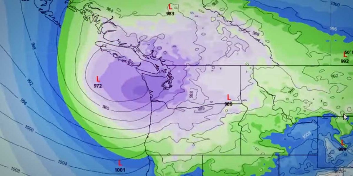
Another windy day is in store for Tuesday as the next low pressure and cold front move into Western Washington. Strong wind gusts will range from 30 to 40 mph from King County northward, and 40 to 50 mph southward (including portions of the Olympic Peninsula). #WAwx pic.twitter.com/dLv9RGhg14
— NWS Seattle (@NWSSeattle) December 26, 2022
@SEACityLight bright flash and loud crack this morning in Burien @ SW 134th St. & 6th Ave SW. Power is out west of 6th Ave SW and the surge arrestors look like they broke or fell down on this pole. pic.twitter.com/zOCp0m57FS
— Jacob Stone (@jcbstn) December 26, 2022
I’m in Burien in a condo and I thought someone was hosing down the siding this morning the rain was so loud, and sideways!
— Seattle Nurse (@seattlenurse) December 26, 2022